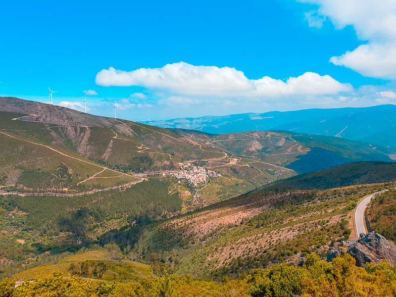
Between the mountains of Lousã and Estrela, rises the Serra do Açor. It is the schist mountain formation that reaches the highest altitude (1418m) and the fifth highest in Portugal Mainland.
Here is born the Ceira River and from here flow waters that feed the Zêzere and Alva, all running at the bottom of narrow valleys. The quality of their waters and the landscape surrounding their banks created the ideal conditions for exceptional river beaches to be established here.
Its slopes and valleys are home to countless villages whose angular, rough-hewn brownstone buildings almost blend into the landscape. The steepness of the slopes makes it difficult to hold the soil.
So, around the villages, more brown stones were piled up creating linear walls that insist on holding the land and people to possible agriculture.
Here and there, some alignments of quartzite rocks will introduce a wild touch to the always rounded shapes of the schist mountain peaks.
We will find them in the Penedos do Fajão and in Serra do Vidual split by Unhais River, but which Man covered again with the construction of Santa Luzia Dam.
PR1 AGN – Benfeita Schist Trail – Freshness of the Waterfalls
Enjoy 10 km of rugged terrain with rounded contours.
“In Açor, a shale domain, the folds and fractures create a characteristic type of relief, vigorous but with rounded contours, furrowed by valleys with large drops in level, embedded water lines and where sometimes curious geological accidents are found, such as the waterfalls of Fraga da Pena.”
The Benfeita Schist Trail is a circular route, starting from the town center.
Along the way, we come into contact with small but fantastic waterfalls, as well as with the transformations of the landscape, the result of centuries of human action.
Once at the top of the rocky ridge, the view over the entire valley is breathtaking and makes all the effort worthwhile.
The path passes through the area of Protected Landscape of Serra do Açor, where we find the diversion for a short descent to Fraga da Pena, an area of impressive waterfalls.
PR 2 and PR 3 AGN – Walk between Piódão, Foz d’Égua and Chaz d´Égua
One of the activities you can enjoy is hiking through the beautiful Serra do Açor, one of the most interesting hiking trails is the one between Piódão, Foz d'Égua and Chaz d'Égua.
The circular route begins and ends at Largo Cónego Manuel Nogueira and connects the village of Piódão to Foz d'Égua or Chaz d'Égua. It's a gently sloping route, with one or two exceptions.
Some abandoned houses along the way are a reminder of pastoral activity. In the clearings, beehives can be seen, a testament to the beekeeping activity that still exists in some areas of the Serra do Açor.
PR4 AGN – Vila Cova de Alva Schist Trail
The route starts at Aldeia do Xisto from Vila Cova de Alva, following the riverbank and taking you through agricultural paths and pine forests, shale terraced stairs and watermills.
The trail begins in the interior of Vila Cova de Alva, through streets with centuries-old architectural details, churches, and shrines that you can visit. The walk takes you along farm paths and pine forests, terraced schist stairs, and watermills, following the banks of the Alva River and passing corners where native vegetation takes on lush forms.
Get ready to admire the best-preserved and lush native vegetation in the region and the panoramic views of the village and the Alva Valley.
Additionally, you can enjoy mountain biking, canoeing, water sports and climbing in Serra do Açor.